Acerca de Todos los tours Tours de 3 díasTours privadosTours desde La PazTours desde San PedroTours al atardecerTours nocturnos de observación de estrellas Cómo llegar Horarios y tarifas
Buscar tours 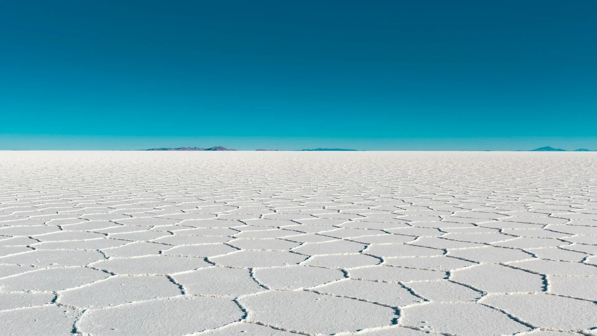
Ten billion tons of salt cover 10,582 square kilometers of the Bolivian Altiplano to form Salar de Uyuni. The high-altitude basin sits at 3,653 meters above sea level, containing over half of the world's lithium reserves beneath a blinding white crust.
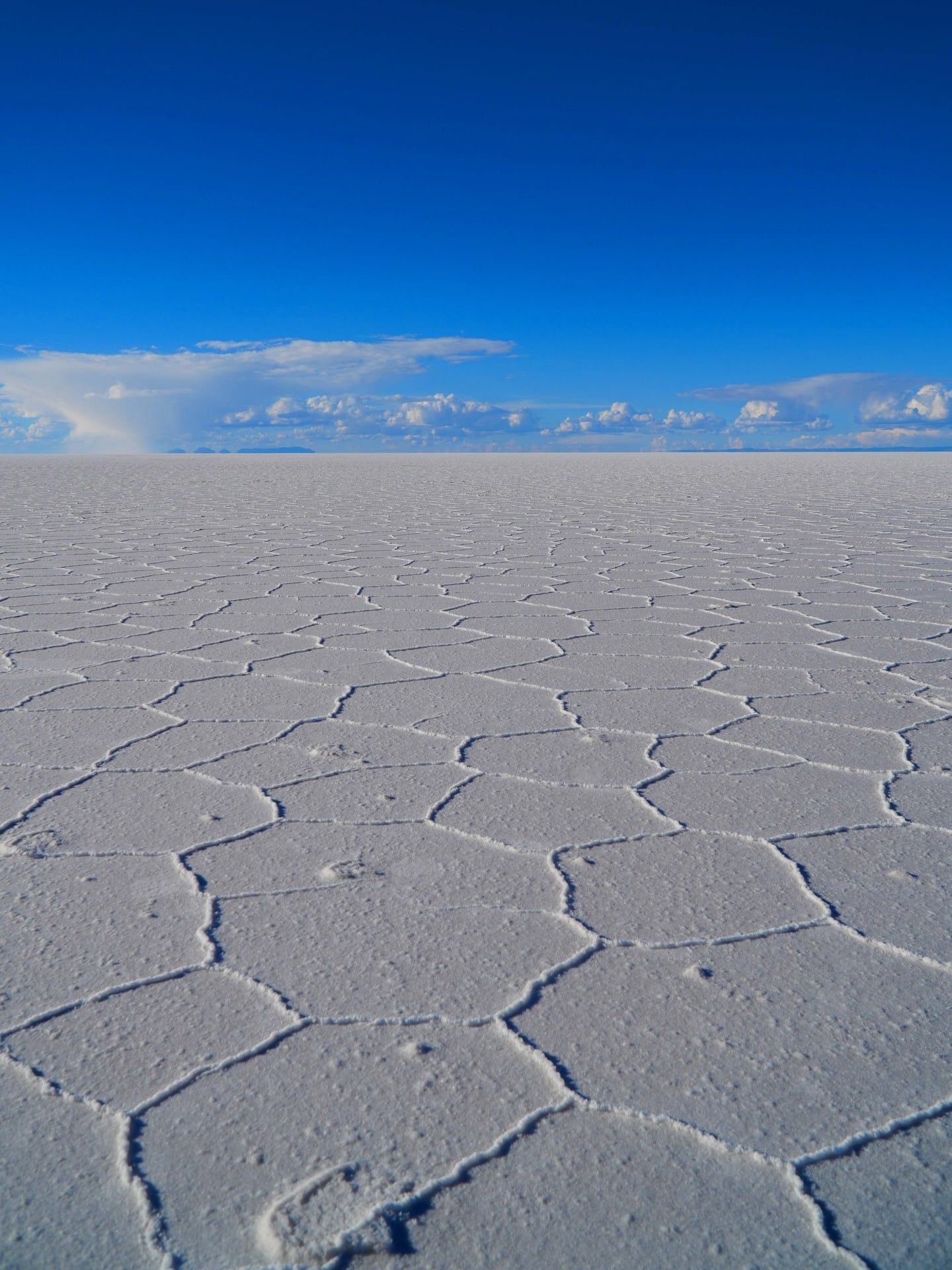
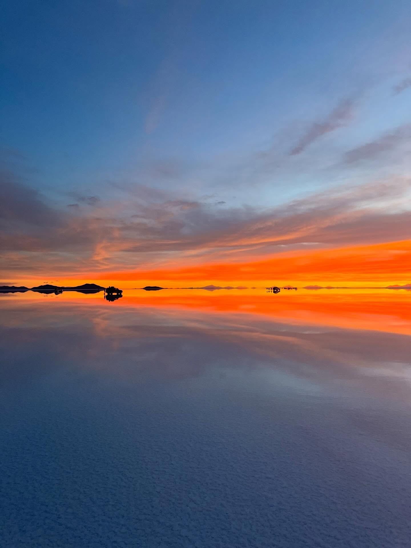
Ten billion tons of salt stretch across 10,582 square kilometers of southwestern Bolivia. Salar de Uyuni occupies a massive, semi-arid basin in the Potosí Department, resting at an elevation of 3,653 meters near the crest of the Andes Mountains. A blinding white crust dominates the landscape. During the dry season from May to November, the surface fractures into repeating hexagonal tiles that vanish into the horizon. Rain alters the terrain entirely between December and March. Ten inches of annual precipitation leave a thin layer of water over the impermeable salt, transforming the ground into a 126-kilometer-long mirror that reflects the sky and clouds.
Beneath the stark white surface lies 50 to 70 percent of the world's lithium reserves. Brine pools trapped under the crust hold the critical mineral required for global smartphone and laptop batteries. Above ground, the expanse is so flat that international space agencies use the surface to calibrate satellite altimeters. The lack of visual depth cues across the 84-kilometer width removes standard perspective. Objects in the distance appear to sit on the same plane as those inches away from the viewer.
Reaching the basin requires a 550-kilometer journey from La Paz. Overnight buses operated by Todo Turismo and Trans Omar depart the capital at 8:00 PM, arriving in Uyuni by 6:00 AM. Flights via Boliviana de Aviación cover the distance in one hour, landing 10 minutes from the town center. Visitors choose between a one-day tour in a 4x4 jeep or a three-day expedition extending to the Chilean border. Standard group tours require travelers to store folding wheelchairs in the trunk and manually transfer into the vehicles. Specialized operators in Uyuni town provide modified 4x4s equipped with lifts for mobility-impaired guests.
Visiting requires enduring harsh conditions. Daytime temperatures burn skin through intense UV radiation, while nighttime temperatures drop below freezing. January and February bring heavy water accumulation that makes the salt flat impassable for vehicles, blocking access to central landmarks. Travelers must carry Bolivian Bolivianos for all transactions, as local attractions and public restrooms reject US dollars.
Thirty thousand years ago, a giant prehistoric body of water known as Lake Minchin covered this section of the Altiplano. The region lacked drainage outlets to the ocean. Water pooled in the high-altitude basin, creating a massive inland sea named after geologist Juan B. Minchin. Climate shifts between 13,000 and 26,100 years ago caused the water level to drop, transitioning the basin into Paleo Lake Tauca. This secondary lake reached a maximum depth of 140 meters before shrinking further into Lake Coipasa around 11,500 years ago.
Intense evaporation eventually outpaced precipitation. The final prehistoric lakes dried up completely, leaving behind concentrated salt deposits that hardened into a crust up to 130 meters thick. Indigenous Aymara and Quechua communities settled the surrounding regions. Local campesinos began harvesting the surface salt using traditional picks and shovels, gathering the minerals into small conical mounds to dry under the sun. This manual extraction method continues today in villages like Colchani, removing less than 25,000 tons annually from the 10-billion-ton reserve.
Industrial focus shifted to the region in the late 20th century. NASA's Project ERTS conducted the first major scientific research on the basin's mineral resources between 1973 and 1976. Satellite imagery revealed the vast lithium deposits suspended in the brine beneath the salt crust. In 1988, the Bolivian government invited the Lithium Corporation of America (LITHCO) to extract the minerals. The contract sparked immediate protests from local communities concerned about environmental degradation and economic exploitation.
The 1940s marked the end of another local industry just outside the salt flat. Steam locomotives that once hauled gold, silver, and tin to Pacific ports were abandoned on the edge of Uyuni town. The rusted, hollowed-out trains now sit in the Cementerio de Trenes, covered in graffiti and corroded by the harsh, salty winds. Travelers climbing on the metal frames should check for sharp edges before taking photographs.
A 130-meter-thick crust of sodium chloride caps the Salar de Uyuni. The surface spans 126 kilometers in length and 84 kilometers in width, maintaining an elevation variance of less than one meter across the entire expanse. This extreme flatness forces cold underground rivers and pressurized air to seek weak points in the crust. At the Ojos del Salar, these subterranean forces break through the salt. Acidic, mineral-rich water bubbles to the surface, churning visibly against the surrounding white plains.
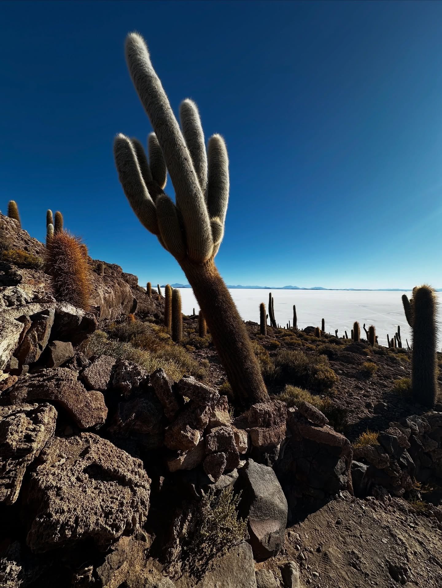
Volcanic rock breaks the flat horizon at Incahuasi Island. The landmass rises abruptly from the center of the salt flat, covered in fossilized coral and giant cacti that grow up to several meters tall. A 15-minute hiking trail winds over the sharp, uneven volcanic terrain to the summit. Visitors scrambling over these rocks face a steep incline at 3,653 meters of elevation, demanding slow, deliberate steps to avoid acute altitude sickness.
The landscape shifts dramatically south of the salt flats along the three-day tour route. The Salvador Dalí Desert features wind-swept, naturally sculpted rock formations surrounded by perfectly conical volcanoes. Further south, Laguna Colorada displays vibrant red waters filled with thousands of grazing pink flamingos, contrasting sharply against white borax deposits along the shoreline.
Geothermal activity intensifies near the Chilean border at the Sol de Mañana Geysers. The elevation climbs to 5,000 meters, where boiling mud pools and sulfurous vents release thick columns of steam into the freezing morning air. The ground around the geysers remains highly unstable. Tourists walking too close to the edge risk falling through the thin crust into boiling mud, making strict adherence to guide instructions a matter of physical safety.
Local indigenous communities view the salt flat through the lens of Andean mythology. Aymara legends state the mountains surrounding the basin—Tunupa, Kusku, and Kusina—were once giant humans. Tunupa married Kusku, but he abandoned her for Kusina. Tunupa's tears mixed with breast milk while she nursed her son, flooding the plain to create the Salar. Tunupa Volcano, rising 5,321 meters on the northern edge of the salt flat, bears her name and remains a sacred site. At its base, the Coquesa Mummies Museum houses ancient human remains preserved by the dry, freezing climate.
Salt harvesting dictates the economic and social rhythm of border towns like Colchani. Artisans carve blocks of solid salt into furniture, bricks, and small sculptures sold in local markets. Local campesinos use traditional picks and shovels to gather the surface salt into large conical mounds. The entire architecture of the region adapts to the environment, culminating in hotels constructed entirely from salt blocks extracted directly from the basin.
Surviving the environment requires strict adherence to local guidelines. Visitors must dress in thermal base layers, windproof jackets, and wide-brimmed hats to handle the extreme temperature shifts. Single-use plastics are discouraged, and travelers must carry out all trash, including biodegradable toilet paper used during outdoor stops. Tourism salaries rely heavily on the tipping culture surrounding the 4x4 drivers and guides. Visitors hand over $5 to $10 USD per day directly to the staff navigating the featureless terrain. Drivers work long hours in extreme conditions, fixing frequent vehicle breakdowns caused by the corrosive saltwater that eats through metal undercarriages.
International space agencies use the extreme flatness of the salt crust to calibrate satellite altimeters from orbit.
The brine pools beneath the surface hold 50 to 70 percent of the world's lithium supply.
Thousands of pink flamingos graze in the nearby red waters of Laguna Colorada at 4,200 meters.
Abandoned 19th-century steam locomotives rust in the open desert just outside the town of Uyuni.
Incahuasi Island features centuries-old cacti growing on fossilized coral in the center of the salt flat.
A thin layer of summer rain creates a 10,582-square-kilometer reflection of the sky between December and March.
Locals extract 25,000 tons of salt annually using traditional picks and shovels to preserve the environment.
The salt flat sits at an elevation of 3,653 meters (11,995 feet) above sea level. The highest point on the standard three-day tour reaches 5,000 meters at the Sol de Mañana Geysers. Visitors commonly experience altitude sickness and require acclimatization before traveling.
A basic one-day tour of the salt flats costs between $30 and $50 USD per person. Comprehensive three-day group tours starting from Uyuni range from $150 to $200 USD. This price includes shared 4WD transport, basic accommodation, and meals.
Yes, US citizens must pay $160 USD for a tourist visa on arrival. The application requires bringing two ID-sized photos to the border crossing. Many Western European and South American citizens can enter visa-free.
The wet season from December to March leaves a thin layer of water on the surface, creating a massive mirror effect. The dry season from May to November exposes repeating hexagonal salt crust patterns. Heavy rain in January and February can make the central salt flat impassable for vehicles.
Tour operators do not include local entrance fees in their base price. Visitors must pay 30 BOB for Incahuasi Island and 150 BOB for the Eduardo Avaroa National Reserve. These fees must be paid in cash using Bolivian Bolivianos.
Independent driving is technically possible but strongly discouraged. The 10,582-square-kilometer expanse lacks roads and landmarks. Drivers easily become disoriented or damage their vehicles in deep saltwater.
Photographers need ziplock bags or dry bags to shield cameras from corrosive salt, dust, and high humidity. Bringing extra batteries is mandatory. The freezing Altiplano temperatures drain electronic batteries rapidly.
Public bathrooms exist at specific stops and cost 6 BOB per use. Multi-day tours often require using natural outdoor toilets in remote desert areas. Travelers must pack their own biodegradable toilet paper and carry it out.
Visitors must pack thermal base layers, warm mid-layer fleeces, and windproof outer shells. Nighttime temperatures drop below freezing, requiring hats and gloves. Daytime conditions demand wide-brimmed hats, UV-protective sunglasses, and SPF 50 sunscreen.
Overnight buses depart La Paz between 8:00 PM and 9:00 PM, arriving in Uyuni 10 to 12 hours later for $15 to $25 USD. Flights via Boliviana de Aviación take one hour and cost $89 to $150 USD. The Uyuni airport sits 10 minutes from the town center.
Explora tours verificados con cancelación gratuita y confirmación instantánea.
Buscar tours